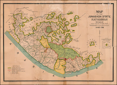
In our previous post, we introduced the blog and shared my passion for collecting Soruth stamps. Today, we dive deeper into the significance of the Soruth map and how it serves as a valuable reference in our philatelic endeavors.
Map Description:
It's important to understand - Saurashtra, was formerly known as Soruth (Sorath), which was formerly known as Junagadh. Hence, my starting search point is different maps of Junagadh state.
Importance in Philately:
Maps are essential tool for collectors, presents a visual representation of the region. It depicts the boundaries, landmarks, and territories. It serves as a key reference when examining postal covers and cancellations. The map helps us analyze cancellations, postmarks, and other postal markings, enabling a deeper understanding of Soruth's postal system.
Map Variations:
While researching the Junagadh state map, you may come across different versions or variations. These variations could stem from different editions or updates over time. Exploring these differences and their implications adds another layer of intrigue to our philatelic research. I will keep updating maps below which I come across in my search and find useful. Remember, each stamp tells a unique story, and the Soruth map is our guide to uncovering those tales. Happy collecting!
 |
| Junagadh State Kathiawar . . . 1938-39 |
 |
| Junagadh State 1913 |
 |
| Kathiawar Map 1878 |
